Rwenzori Mountains National Park protects the legendary "Mountains of the Moon", a snow-capped range on Uganda's border with the DR Congo. Here, glaciers sit almost on the Equator, giant lobelias and groundsels grow taller than people, and Margherita Peak rises to 5,109 metres, the highest point in Uganda and the third-highest in Africa.
The park is a UNESCO World Heritage Site and a Ramsar wetland of international importance. It offers everything from gentle day hikes in the foothills to a technical climb onto the glaciers, and it is wonderfully quiet: you will share the trails with only a handful of other trekkers.
This complete guide covers the peaks, the hiking routes, wildlife and plants, the best time to go, fees, where to stay, how to get there and how to choose the right Rwenzori trek for you.
Get a Free Rwenzori Trek Quote on WhatsApp
Rwenzori Mountains National Park at a Glance
| Location | Western Uganda, on the DR Congo border, between Kasese and Fort Portal |
| Size | 996 square kilometres; the range is about 120 km long and 65 km wide |
| Highest point | Margherita Peak, Mount Stanley, 5,109 m |
| Status | National park 1991, UNESCO World Heritage Site 1994, Ramsar site 2008 |
| Main trails | Central Circuit (from Nyakalengija) and Kilembe Route (from Kilembe) |
| Trek lengths | Day hikes to 9 or more days for Margherita Peak |
| Wildlife | About 70 mammals and 217 birds, including Albertine Rift endemics |
| Entrance fee | US$35 foreign non-resident adult per day |
| Managed by | Uganda Wildlife Authority |
Why Visit Rwenzori Mountains National Park?
- Snow on the Equator: the Rwenzori glaciers lie less than 50 km north of the Equator, one of the few places on Earth where that happens.
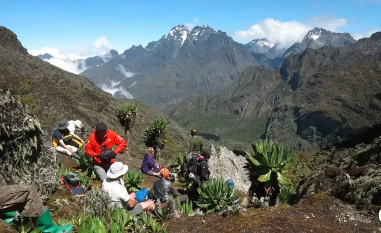
- A landscape like nowhere else: giant lobelias, giant groundsels, moss-draped trees and bright everlasting flowers make the higher slopes look like another planet.
- Africa's third-highest summit: Margherita Peak is a true mountaineering challenge, harder than Kilimanjaro and Mount Kenya.
- Treks for every level: you do not need to be a climber. Day hikes and 2 to 6 day treks reach lakes, viewpoints and peaks without ropes.
- Few crowds: the Rwenzoris see a tiny share of the visitors that climb Kilimanjaro.
- Easy to combine: it sits next to Queen Elizabeth National Park, Kibale Forest and Fort Portal's crater lakes.
The Peaks of Rwenzori Mountains National Park
The mountains of Rwenzori Mountains National Park are not volcanoes. They are a block of ancient rock pushed up between two arms of the Albertine Rift, which is why they are so steep and rugged. The range has six main mountains, each with several peaks:
| Mountain | Highest peak | Height |
| Mount Stanley | Margherita Peak | 5,109 m |
| Mount Speke | Vittorio Emanuele Peak | 4,890 m |
| Mount Baker | Edward Peak | 4,843 m |
| Mount Emin | Umberto Peak | 4,798 m |
| Mount Gessi | Iolanda Peak | 4,715 m |
| Mount Luigi di Savoia | Weismann's Peak | 4,620 m |
Only Mount Stanley rises above 5,000 metres, but all six are high enough to hold snow or glaciers for at least part of the year. Compare them with Africa's other great summits in our guides to Mount Kilimanjaro and climbing Mount Kenya.
The Shrinking Glaciers
The glaciers of Rwenzori Mountains National Park have shrunk dramatically over the past century as the climate warms, and scientists warn they could disappear within a few decades. If you dream of walking on equatorial ice, now is the time to go.
The Story of the Mountains of the Moon
Around 150 AD, the Greek-Egyptian geographer Ptolemy wrote of snowy "Mountains of the Moon" that fed the River Nile. The name stuck, although the Nile's main source was later traced to Lake Victoria, where you can visit the source of the Nile at Jinja. The Rwenzoris do still feed the Nile system through rivers that flow into Lakes Edward and Albert.
The name Rwenzori is often linked to the local phrase rwe nzururu, meaning "place of snow". The Bakonzo people of the foothills hold the snow sacred and believe their god Kitasamba lives on the peaks.
European explorers reached the range in the late 1800s, and in 1906 the Duke of the Abruzzi led the first major expedition, climbing and naming many of the peaks. The area became a national park in 1991, a UNESCO World Heritage Site in 1994 and a Ramsar wetland in 2008.
Vegetation Zones of Rwenzori Mountains National Park
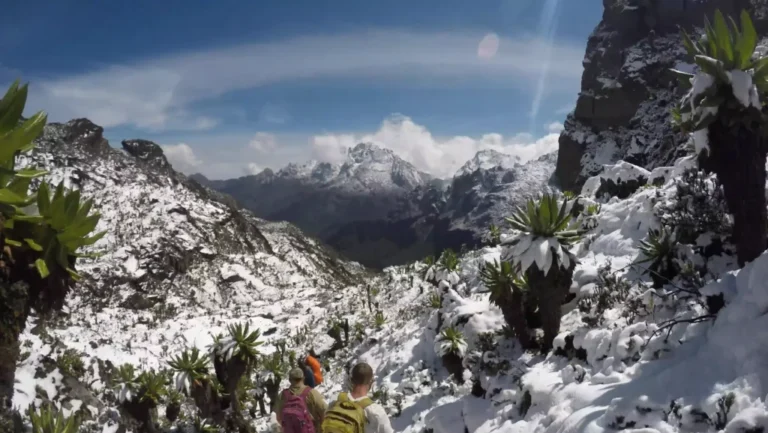
Climbing in Rwenzori Mountains National Park is like walking from the tropics to the Arctic. Each band of altitude has its own world:
- Montane forest (about 1,800 to 2,500 m): tall trees, tree ferns, wild orchids and most of the park's primates and birds.
- Bamboo and mimulopsis (about 2,500 to 3,000 m): dense bamboo thickets, often wet and muddy underfoot.
- Heather zone (about 3,000 to 3,800 m): giant tree heathers draped in thick moss and old man's beard lichen, with bogs between them.
- Afro-alpine zone (about 3,800 to 4,500 m): the famous giant lobelias and groundsels, everlasting flowers and glacial lakes.
- Rock and ice (above 4,500 m): bare rock, snowfields and glaciers.
Wildlife and Birds in Rwenzori Mountains National Park
Most visitors come to Rwenzori Mountains National Park for the scenery, but the forests are rich in life. The park is home to about 70 mammal species, including chimpanzees, L'Hoest's and blue monkeys, black-and-white colobus, forest elephants, duikers, hyraxes and the three-horned chameleon.
Around 217 bird species have been recorded, including many Albertine Rift endemics. Look for the Rwenzori turaco, Rwenzori batis, Archer's robin-chat, handsome francolin, blue-headed sunbird and the colourful Rwenzori double-collared sunbird. Birding is best in the forest zone, on day hikes and the first days of longer treks.
Ways to Hike in Rwenzori Mountains National Park
1. Day Hikes and Nature Walks
Short guided walks in the foothills are the easiest way to experience Rwenzori Mountains National Park. Trails pass through montane forest and along mountain rivers to waterfalls and viewpoints, with good chances of birds and monkeys. Community walks visit Bakonzo villages for music, dance and stories.
These are perfect if you are short on time or not ready for a multi-day trek. See more options in our 13 best day hikes in Uganda.
2. Short Treks of 2 to 4 Days
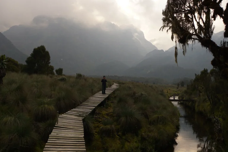
Short treks take you through the forest and bamboo zones into the heather, sleeping in mountain huts. The 4-day hike to the Mutinda Lookout at 3,975 metres is a favourite, with views over the range and a taste of the alpine landscape, and it is a great acclimatisation trek before a summit climb.
3. Non-Technical Trek to Weismann's Peak
Fit hikers who do not want ropes or ice can reach Weismann's Peak (4,620 m) on Mount Luigi di Savoia in about 6 days via the Kilembe Route. You pass through every vegetation zone, see glacial lakes and giant lobelias, and stand on a true Rwenzori summit with views of the glaciers.
4. Technical Climb to Margherita Peak
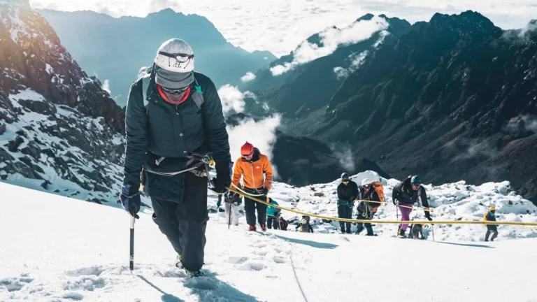
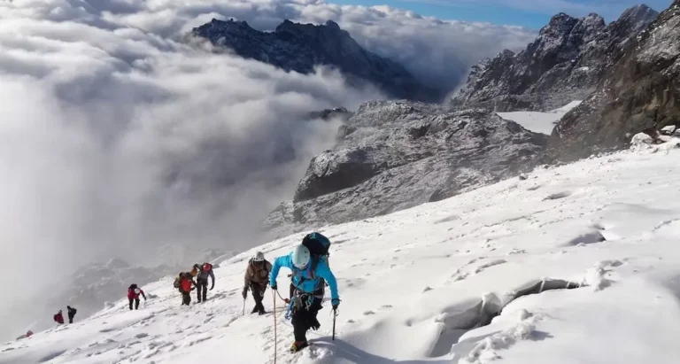
The climb to Margherita Peak (5,109 m) is the ultimate Rwenzori adventure. The final day crosses the Stanley Plateau and the Margherita Glacier using crampons, ice axes and ropes, with experienced mountain guides. Most itineraries take 8 to 10 days, including acclimatisation days.
No previous ice-climbing experience is strictly required, but you must be very fit, comfortable at altitude and happy on steep, slippery ground. Guides teach the basic skills before the summit day.
Rwenzori Mountains National Park Routes: Central Circuit vs Kilembe
| Feature | Central Circuit | Kilembe Route |
| Starting point | Nyakalengija, near Kasese | Kilembe, near Kasese |
| Side of the range | East and north, a loop | South, up the Mubuku and Nyamwamba valleys |
| Character | The classic route, with famous bogs and lakes | A more gradual climb, with boardwalks and upgraded huts |
| Popular trips | 7 to 9 day circuit, Margherita Peak | Mutinda Lookout, Weismann's Peak, Margherita Peak |
Both routes reach Margherita Peak. We will recommend the best route for your fitness, time and budget.
Help Me Choose a Rwenzori Route
Our Rwenzori Mountains National Park Treks
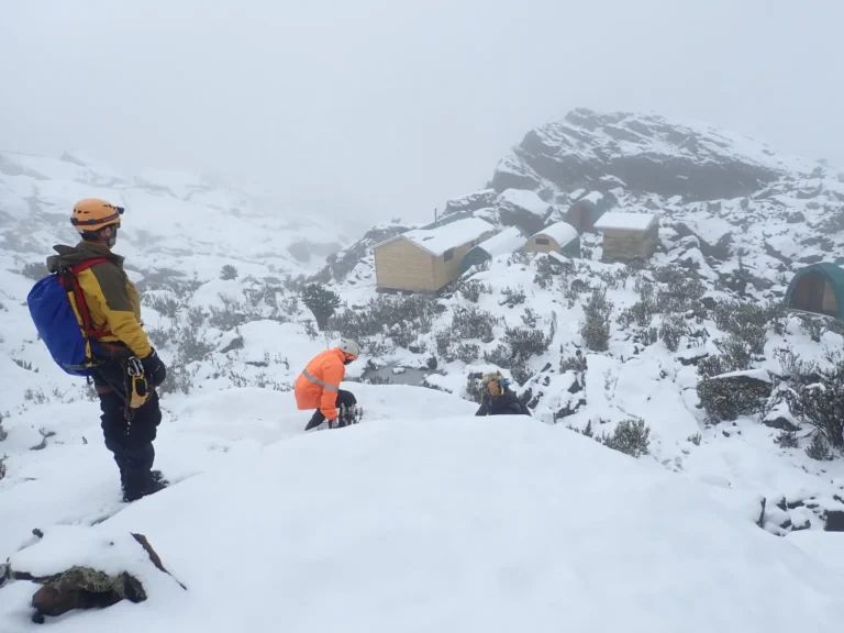
We run private and small-group treks in Rwenzori Mountains National Park for every level:
- 2-Day Rwenzori Mountains Trek: a short taste of the forest and foothills.
- 3-Day Rwenzori Mountains Hike via the Kilembe Trail: into the bamboo and heather zones.
- 4-Day Rwenzori Hike to the Mutinda Lookout: views over the range at 3,975 m.
- 6-Day Rwenzori Trek to Weismann's Peak: a non-technical summit at 4,620 m.
- 15 Days Active Uganda Adventure with Rwenzori Trekking: combine the mountains with gorillas, chimps and game drives.
For Margherita Peak, contact us for a tailor-made itinerary. Browse more trips in our Uganda hiking safaris and Uganda safaris and tours.
What to Expect on a Trek in Rwenzori Mountains National Park
- Expert support: certified mountain guides lead every trek, porters carry the bags and food, and cooks prepare hot meals each evening.
- Mountain huts: nights are spent in simple huts with bunks. Bring a warm sleeping bag.
- Mud and bogs: the Rwenzoris are among the wettest mountains in Africa. Expect mud, roots and bogs, even in the drier months, so gumboots are standard.
- Altitude: above 3,000 metres, take it slowly, drink plenty of water and tell your guide about headaches or nausea.
- Changing weather: sun, mist, rain and even snow can come in a single day.
Best Time to Visit Rwenzori Mountains National Park
Rwenzori Mountains National Park can be hiked all year, but the drier months of June to August and December to February are best. Trails are a little less muddy, and the chance of clear summit views is higher.
March to May and September to November are the wettest months, when bogs deepen and the peaks are often hidden in cloud. Even in the dry season, rain is likely on some days, so pack for wet weather whenever you go. For the rest of the country, see our guide to the best time to visit Uganda.
Rwenzori Mountains National Park Fees and Costs
| Visitor category | Park entrance (per day) |
| Foreign non-resident | US$35 |
| Foreign resident | US$25 |
| East African citizen | UGX 15,000 |
On multi-day treks, park fees are paid for each day on the mountain. The full trek price also covers guides, porters, huts, meals, rescue fees and, for Margherita Peak, climbing equipment.
The total depends on the route, the number of days and your group size, so a 3-day hike costs far less than a 9-day summit climb. Uganda Wildlife Authority updates its tariff from time to time, so we confirm all rates in your quote.
How to Get to Rwenzori Mountains National Park
Both main trailheads of Rwenzori Mountains National Park, Nyakalengija and Kilembe, are close to Kasese town at the foot of the mountains.
Driving Times to the Rwenzori Trailheads
| From | Approximate drive time |
| Kampala via Fort Portal (about 380 km) | 6 to 7 hours |
| Kampala via Mbarara | 7 to 8 hours |
| Fort Portal | About 1.5 hours |
| Queen Elizabeth National Park | 1 to 2 hours |
| Kibale Forest National Park | About 2 hours |
Light aircraft can also fly from Entebbe or Kajjansi to the Kasese airstrip, saving a long day on the road. We can arrange the flight and transfer to the trailhead.
Where to Stay Near Rwenzori Mountains National Park
- Before and after your trek: lodges and guesthouses near Nyakalengija and Kilembe let you start early and rest after coming down.
- Kasese town: comfortable hotels for all budgets, about 30 minutes from the trailheads.
- Fort Portal: crater-lake lodges and town hotels, ideal if you are combining the mountains with Kibale Forest.
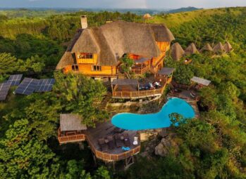
- On the mountain: simple huts run by the trekking operators, included in your trek.
Tell us your budget, and we will match the lodge to your trek.
Combine the Rwenzoris With a Uganda Safari
After the cool mountain air, a safari in the warm savannah is the perfect reward. Queen Elizabeth National Park lies just south of the range, with tree-climbing lions and the Kazinga Channel. To the north, you can track chimps in Kibale and explore Fort Portal's crater lakes.
Many travellers end with gorilla trekking in Bwindi Impenetrable Forest or Mgahinga Gorilla National Park. Read our guides to Queen Elizabeth National Park and Kibale Forest National Park to plan your route.
Packing List for Rwenzori Mountains National Park
- Gumboots for the mud, plus light hiking shoes for camp
- Waterproof jacket and trousers, and a warm fleece or down jacket
- A warm sleeping bag rated to around minus 10 °C
- Gloves, a warm hat, sunglasses and sunscreen
- Trekking poles, a headtorch and a waterproof bag cover
- Water bottles, purification tablets and personal medication
Climbing equipment for Margherita Peak is provided by the operator.
Plan Your Margherita Peak Climb
Rwenzori Mountains National Park FAQs
Where is Rwenzori Mountains National Park?
In western Uganda on the border with the DR Congo, between Kasese and Fort Portal. The main trailheads are near Kasese.
What does Rwenzori mean?
The name is often linked to the local phrase rwe nzururu, meaning "place of snow". The range is also called the Mountains of the Moon.
How high is Margherita Peak?
Margherita Peak on Mount Stanley is 5,109 metres, the highest point in Uganda and the third-highest in Africa after Kilimanjaro and Mount Kenya.
How long does it take to climb the Rwenzori Mountains?
Day hikes take a few hours. Short treks take 2 to 4 days, Weismann's Peak about 6 days, and Margherita Peak usually 8 to 10 days.
Do I need climbing experience for the Rwenzoris?
Not for day hikes, short treks or Weismann's Peak. Margherita Peak crosses glaciers with ropes and crampons, so you need excellent fitness, and guides teach the basic skills.
How much does it cost to climb the Rwenzori Mountains?
It depends on the route, number of days and group size. Park entry is US$35 per day for foreign non-residents, and the full trek price adds guides, porters, huts, meals and equipment. Contact us for a quote.
When is the best time to hike the Rwenzoris?
June to August and December to February are the driest months, with the best chance of clear views. Expect some rain and mud at any time of year.
Is the Rwenzori harder than Kilimanjaro?
Yes, for most people. Kilimanjaro is higher, but the Rwenzori summit needs glacier travel, and the trails are steeper, muddier and wetter.
Plan Your Rwenzori Mountains Adventure
Tulambule Uganda Safaris is 100% Ugandan-owned, accredited by the Uganda Tourism Board and the Uganda Wildlife Authority, and rated 4.9 stars on TripAdvisor. We have planned treks and safaris across Uganda since 2014, and we work with experienced Rwenzori guides and operators on both routes.
Call or WhatsApp +256 782 915 447 or email info@tulambule.com for a free quote, whether you want a day hike, a short trek or the summit of Margherita Peak.